So you’re curious about how GPS systems can help out in farming, huh? Well, let me tell you, it’s quite fascinating how these small devices can make a big difference in the agricultural world. With GPS systems, farmers can precisely navigate their way through vast fields, ensuring accurate seed placement and optimal fertilizer distribution.
Not only that, but these systems also provide real-time data on soil conditions, weather patterns, and crop health, enabling farmers to make informed decisions to maximize their yield and minimize their impact on the environment. Sound interesting? Keep reading to discover more about the incredible ways GPS systems aid in farming.
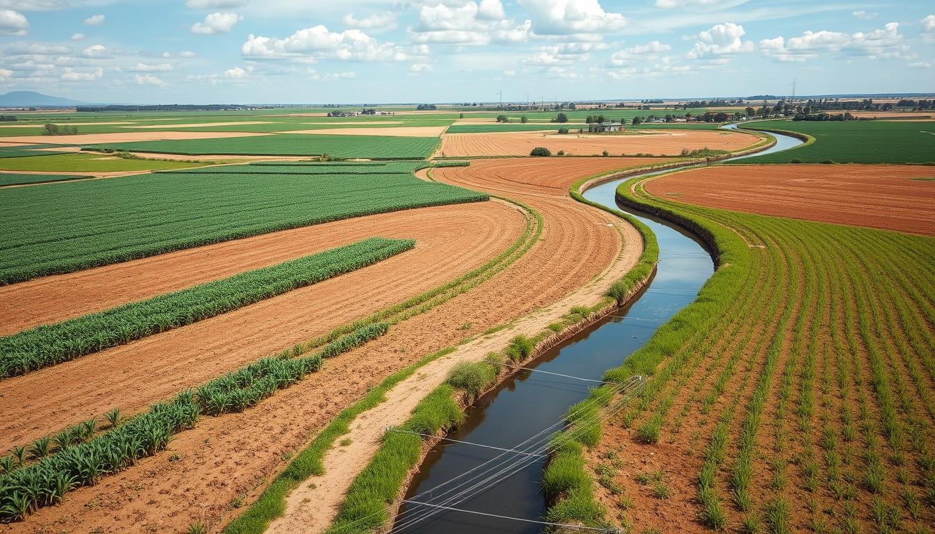
Improving Efficiency in Field Operations
Precise Navigation for Field Work
One of the key ways GPS systems aid in farming is by providing precise navigation for fieldwork. By utilizing satellite technology, GPS systems can accurately determine the exact location of farm equipment and vehicles in the field. This allows farmers to navigate their machinery with precision, ensuring optimal field coverage and minimizing overlap. With precise navigation, farmers can save time, reduce fuel consumption, and increase overall efficiency in their field operations.
Optimizing Field Layouts
GPS systems also play a vital role in optimizing field layouts. By utilizing GPS technology, farmers can accurately map out their fields, identifying areas that may need specific attention or adjustments. This information can be used to create precise field boundaries, enabling farmers to efficiently manage different areas of their land. By optimizing field layouts, farmers can ensure proper resource allocation, maximize crop productivity, and reduce waste.
Effective Route Planning
Another benefit of GPS systems in farming is the ability to effectively plan routes for field operations. With GPS technology, farmers can analyze field topography, soil conditions, and other relevant factors to determine the most efficient routes for seeding, spraying, and harvesting. This optimization of routes saves time and ensures that crops receive the necessary attention and resources. By reducing unnecessary trips and improving route planning, farmers can increase productivity and minimize costs.
Enhancing Precision Agriculture
Accurate Yield Mapping
GPS systems contribute to precision agriculture by enabling accurate yield mapping. By using GPS technology to track the position of farm equipment during harvest, farmers can create detailed maps of crop yield variability across their fields. This data provides valuable insights into the productivity of different areas, allowing farmers to make informed decisions regarding crop selection, fertilization, and irrigation. Accurate yield mapping helps optimize overall crop management and maximize farm profitability.
Variable Rate Application
Another aspect of precision agriculture that GPS systems enhance is variable rate application. By integrating GPS technology with farm equipment, farmers can apply inputs such as seeds, fertilizers, and pesticides at variable rates based on the specific needs of different areas of their fields. By precisely tailoring input applications to meet the requirements of each crop zone, farmers can achieve more efficient resource utilization, reduce environmental impact, and improve overall crop health.
Site-Specific Crop Management
GPS systems also enable site-specific crop management, which is a cornerstone of precision agriculture. By accurately mapping out their fields and utilizing GPS-guided equipment, farmers can apply targeted treatments to address specific crop needs. This may include interventions such as precision irrigation, weed control, and disease management. By focusing resources and interventions where they are needed the most, farmers can optimize crop health and minimize the wastage of inputs.

Improving Crop Monitoring and Management
Real-Time Tracking of Field Activities
GPS systems provide real-time tracking of field activities, which greatly enhances crop monitoring and management. By equipping farm equipment with GPS technology, farmers can monitor the progress and location of their machinery in real time. This information allows farmers to effectively coordinate their activities, adjust their plans if needed, and ensure that all tasks are completed promptly. Real-time tracking also facilitates data collection, which is crucial for making informed decisions regarding crop management.
Monitoring Crop Health and Growth
In addition to tracking field activities, GPS systems enable farmers to monitor crop health and growth more effectively. By integrating GPS with remote sensing technologies such as drones or satellites, farmers can capture high-resolution imagery of their fields. By analyzing this imagery along with GPS data, farmers can identify potential issues such as nutrient deficiencies, pest infestation, or water stress. This timely information allows them to take proactive measures to prevent or manage problems, ultimately optimizing crop health and yield.
Identifying and Managing Pests
GPS systems assist in identifying and managing pests in the field. By combining GPS technology with pest monitoring systems, farmers can accurately pinpoint areas of pest activity. This information helps farmers implement targeted pest management strategies, such as applying pesticides only to affected areas or deploying beneficial insects precisely where they are needed. By reducing the reliance on broad-spectrum treatments, farmers can minimize environmental impact and protect beneficial organisms in the ecosystem.
Effective Irrigation Management
Efficient irrigation management is crucial for crop health and productivity, and GPS systems can greatly assist in this area. By utilizing real-time data from weather stations, soil moisture sensors, and GPS-guided irrigation equipment, farmers can optimize their irrigation practices. GPS technology enables precise mapping of irrigation zones and the delivery of water based on specific crop needs and soil moisture levels. By avoiding under or over-irrigation, farmers can conserve water resources, reduce costs, and ensure optimal crop growth.
Enabling Autonomous and Guided Farming
Autonomous Farming Vehicles
GPS systems enable the development and implementation of autonomous farming vehicles. By using GPS technology along with sophisticated sensors and control systems, farmers can automate various field operations. Autonomous vehicles can perform tasks such as seeding, spraying, and harvesting with precision and efficiency, freeing up labor and reducing human error. This technology promises increased productivity, reduced costs, and improved safety in farm operations.
Automated Guided Systems (AGS)
In addition to autonomous farming vehicles, GPS systems facilitate the use of automated guided systems (AGS). AGS utilizes GPS technology to guide farm machinery, ensuring accurate and consistent operation. By incorporating GPS guidance, farmers can reduce overlaps, prevent missed areas, and optimize overall field coverage. AGS technology is particularly beneficial in complex field layouts or on hilly terrains where manual operation may be challenging. AGS enhances efficiency and productivity while minimizing operator fatigue.
Precision Spraying and Seeding
GPS systems also enable precision spraying and seeding, further enhancing efficiency and crop management. By integrating GPS technology with sprayers and seeders, farmers can apply precise amounts of inputs to targeted areas. This ensures that seeds or sprays are distributed evenly and precisely, minimizing waste and optimizing coverage. Precision spraying and seeding technology allow farmers to achieve better weed control, accurate placement of nutrients, and more effective pest management.

Facilitating Farm Machinery Guidance
Steering Assistance System
GPS systems facilitate farm machinery guidance through the use of steering assistance systems. By integrating GPS technology with steering control, farmers can maintain straight, parallel lines during field operations. This reduces overlaps and missed areas, ensuring optimal field coverage. Steering assistance systems also help reduce operator fatigue by allowing them to focus on other aspects of operation rather than constantly steering the equipment. This technology improves efficiency, productivity, and accuracy in the field.
Boundary and Headland Control
Boundary and headland control is another area where GPS systems greatly facilitate farm machinery guidance. By accurately mapping field boundaries and headlands using GPS technology, farmers can program their equipment to automatically stop or turn at predefined points. This technology eliminates the need for manual intervention during headland turns, reducing the risk of operator error and enabling consistent and precise field operations. Boundary and headland control enhance efficiency and overall field management.
Implement Guidance
GPS systems also support implementation guidance, ensuring that equipment such as planters or sprayers follow the desired path. By using GPS technology to guide implements, farmers can achieve accurate and consistent operation, even when working in challenging field conditions. Implement guidance reduces overlap and ensures that inputs are applied precisely where intended. This precision leads to improved crop uniformity and better resource utilization, ultimately increasing productivity and reducing costs.
Improving Record Keeping and Documentation
Logging Field Data
GPS systems play a crucial role in improving record-keeping and documentation on the farm. By automatically recording the position and activities of farm equipment, GPS technology simplifies data collection and management. This data can include information such as field operations, input applications, or yield measurements. By logging field data accurately and automatically, farmers can maintain detailed records of their activities, which can be analyzed and used for future planning and decision-making.
Creating Field Boundaries
GPS systems also facilitate the creation of field boundaries, which are essential for effective farm management. By mapping out field boundaries using GPS technology, farmers can define and manage different areas of their land more efficiently. Field boundaries help farmers track individual field performance, implement variable rate applications, and optimize resource allocation. By creating and maintaining accurate field boundaries, farmers can enhance their overall farm management practices.
Recording Application Rates
Accurate recording of application rates is crucial for effective farm management and compliance with regulations. GPS systems enable farmers to precisely record the rates of fertilizers, pesticides, and other inputs applied to their fields. By integrating GPS with farm equipment, application rates can be automatically recorded and linked to specific field locations. This information helps farmers evaluate the effectiveness of their applications, adjust rates if needed, and ensure compliance with best practices and environmental regulations.

Enabling Farm Safety and Security
Worker Safety Management
GPS systems contribute to farm safety management by providing location tracking and communication capabilities. By equipping farm workers with GPS devices, their whereabouts can be monitored, allowing for quick response in case of emergencies or accidents. GPS technology also enables effective communication between workers in the field and supervisors, enhancing coordination and ensuring that help can be quickly summoned if needed. By utilizing GPS for worker safety management, farms can prioritize the well-being of their employees.
Theft Prevention
GPS systems also aid in farm security by helping prevent theft. By installing GPS tracking devices on valuable equipment and vehicles, farmers can track their assets in real time. This allows for swift recovery in case of theft and serves as a deterrent to potential thieves. GPS technology can also notify farmers of any unauthorized movement or tampering, enabling them to take immediate action. By utilizing GPS for theft prevention, farmers can protect their investments and reduce the risk of financial losses.
Integrating with Farm Management Software
Data Transfer and Analysis
GPS systems integrate seamlessly with farm management software, enabling efficient data transfer and analysis. By utilizing GPS technology to collect field data, farmers can easily transfer this information to software applications for further processing and analysis. This allows farmers to gain valuable insights into their operations, identify trends, and make data-driven decisions. GPS data integration enhances overall farm management and enables continuous improvement in efficiency and productivity.
Task and Activity Planning
GPS systems also assist in task and activity planning on the farm. By utilizing GPS technology, farmers can accurately assess the time required to complete specific field operations. This information helps in scheduling tasks and allocating resources efficiently. By incorporating GPS data into farm management software, farmers can create optimized task lists, assign work to employees, and monitor progress in real time. Task and activity planning with GPS systems enable effective time management and improved overall productivity.
Inventory and Equipment Management
Efficient inventory and equipment management are crucial for a well-functioning farm, and GPS systems contribute to this aspect as well. By integrating GPS technology with inventory and equipment tracking software, farmers can monitor the location and utilization of assets. This helps in preventing equipment loss, optimizing equipment allocation, and ensuring timely maintenance. GPS systems provide real-time information on the status and availability of equipment, enabling farmers to streamline their operations and reduce downtime.

Supporting Environmental Sustainability
Reducing Environmental Impact
GPS systems have a significant role in reducing the environmental impact of farming practices. By enabling precise navigation and guidance, GPS technology helps farmers minimize overlap and optimize input applications. This reduces the use of fertilizers, pesticides, and other inputs, resulting in reduced environmental contamination. GPS systems also facilitate the implementation of precision irrigation techniques, conserving water resources and ensuring efficient water usage. By supporting environmentally responsible practices, GPS systems contribute to the sustainable future of agriculture.
Implementing Conservation Practices
GPS systems also aid in implementing conservation practices on the farm. By accurately mapping field boundaries and topography, farmers can identify areas that require special conservation measures, such as buffer zones or soil erosion prevention. GPS technology guides the placement of conservation structures and allows for precise application of conservation practices. By implementing conservation practices effectively, farmers can protect natural resources, maintain biodiversity, and contribute to long-term environmental sustainability.
Future Developments and Possibilities
Advancements in Precision Technology
The future of GPS systems in farming is full of exciting advancements in precision technology. Improvements in GPS accuracy, along with the integration of other technologies such as remote sensing and machine learning, promise even greater precision and efficiency in farm operations. Enhanced algorithms and sensors will enable more precise mapping, variable rate applications, and real-time data analysis. With ongoing research and development, precision technology will continue to play a pivotal role in shaping the future of agriculture.
Integration with IoT and AI
The integration of GPS systems with the Internet of Things (IoT) and Artificial Intelligence (AI) is another area of future development. By incorporating GPS data with IoT devices and AI algorithms, farmers can achieve real-time monitoring and decision-making capabilities. IoT sensors can collect data on soil moisture, nutrient levels, and weather conditions, while AI algorithms can analyze this information along with GPS data to provide valuable insights and recommendations. This integration will revolutionize farm management, enabling proactive and precise decision-making.
Potential Benefits for Small-Scale Farmers
GPS systems have the potential to benefit small-scale farmers as well. With the increasing availability and affordability of GPS technology, small-scale farmers can access the same precision and efficiency advantages as their larger counterparts. By utilizing GPS systems, small-scale farmers can optimize resource allocation, reduce input usage, and enhance overall farm productivity. The integration of GPS systems with mobile applications and cloud-based platforms further democratizes access to advanced farm management tools, empowering small-scale farmers to thrive in an increasingly competitive industry.
Conclusion
In conclusion, GPS systems have revolutionized modern farming practices by enhancing efficiency, precision, and sustainability. From precise navigation and optimized field layouts to precise crop management and autonomous farming, GPS technology offers a wide array of benefits for farmers. By integrating GPS systems with farm management software and other technologies, farmers can streamline their operations, make data-driven decisions, and embrace a more sustainable and profitable future. With ongoing advancements and innovative developments, GPS systems will continue to transform the agriculture industry for the better.
How can GPS be used for farming?
GPS technology in farming is used for precise navigation, efficient field operations, and improved crop management. It enables accurate seed placement, optimal fertilizer distribution, and real-time monitoring of soil conditions and crop health. GPS also supports autonomous farming vehicles and precision agriculture techniques like variable rate application and yield mapping.
What is navigation in agriculture?
Navigation in agriculture refers to the use of GPS technology to guide farm machinery accurately through fields. It ensures optimal field coverage, reduces overlaps in seeding, spraying, or harvesting, and helps in creating efficient routes for field operations, thereby saving time and resources.
How can GPS be used in mining?
In mining, GPS is used for land surveying, equipment tracking, and precision drilling. It helps in mapping mine layouts, monitoring the movement of equipment, ensuring the safety of operations, and providing accurate data for geological analysis and decision-making.
How can GPS be used in forestry?
GPS is used in forestry for mapping forest areas, tracking tree growth, and managing forest resources. It assists in planning and executing forestry operations, monitoring wildlife habitats, and ensuring sustainable forest management practices.
What are the benefits and uses of GPS in the environment?
GPS technology benefits the environment by enabling sustainable farming practices, reducing the use of chemicals through precision agriculture, and aiding in conservation efforts. It helps in monitoring wildlife, managing natural resources, and conducting environmental research for informed decision-making.
What is the importance of GPS in fieldwork?
GPS is crucial in fieldwork for its accuracy in mapping and data collection. It ensures precise navigation, efficient resource allocation, and effective monitoring and management of field operations. GPS data is vital for informed decision-making and optimizing productivity in various field activities.
How does GPS improve precision in farming operations?
GPS improves precision in farming by enabling accurate navigation, tailored input applications, and detailed monitoring of crop health. It allows for variable rate applications, precise irrigation, and site-specific crop management, leading to efficient use of resources and improved crop yields.
What role does GPS play in crop yield mapping?
GPS plays a vital role in crop yield mapping by tracking the position of farm equipment during harvest and creating detailed maps of crop yield variability. This data helps farmers understand productivity patterns, optimize input use, and make informed decisions about crop management strategies.
How do autonomous farming vehicles utilize GPS?
Autonomous farming vehicles use GPS for navigation and operation without human intervention. GPS guides these vehicles to perform tasks like seeding, spraying, and harvesting with high precision and efficiency, reducing labor requirements and enhancing productivity.
How does GPS integrate with farm management software?
GPS integrates with farm management software by providing accurate field data that can be analyzed for insights. It enables efficient data transfer, task scheduling, resource allocation, and progress monitoring, leading to optimized farm operations and decision-making.
What are the environmental benefits of using GPS in farming?
The environmental benefits of using GPS in farming include reduced chemical usage, efficient water management, and minimized soil disturbance. It supports sustainable practices like precision agriculture and conservation farming, contributing to soil health, biodiversity, and reduced carbon footprint.
How does GPS contribute to efficient irrigation management?
GPS contributes to efficient irrigation management by providing precise data on soil moisture and crop needs. It enables the creation of detailed irrigation zones and the targeted delivery of water, preventing over or under-irrigation, conserving water resources, and ensuring optimal crop growth.
Source Links
- Farmtrack: A cloud-based approach to agricultural vehicle tracking, offering analytics to enhance efficiency.
- GPS tracker for tractors and farm equipment – FarmBackup Task: Real-time machine location tracking with updates every second, providing a trail of movements.
- Farming and Agriculture Solutions Specialists – TG Tracking: Offers a holistic approach to managing all aspects of a farm, with ultra-rugged, long-life battery-powered GPS tracking devices.

HOTOR Car Trash Can with Lid and Storage Pockets - 100% Leak-Proof Organizer, Waterproof Garbage Can, Multipurpose Trash Bin for Car, 2 Gallons, Black
$9.99 (as of 11 December 2025 02:25 GMT +02:00 - More infoProduct prices and availability are accurate as of the date/time indicated and are subject to change. Any price and availability information displayed on [relevant Amazon Site(s), as applicable] at the time of purchase will apply to the purchase of this product.)
Portable Washing Machine, Mini Washer and Spin-Dryer With Folding Hanger, 16L Large Capacity Small Compact Laundry Machine of Underwear, Baby Clothes, for Apartments, Dormitories, RV, Travel, (White)
$53.99 (as of 12 December 2025 02:47 GMT +02:00 - More infoProduct prices and availability are accurate as of the date/time indicated and are subject to change. Any price and availability information displayed on [relevant Amazon Site(s), as applicable] at the time of purchase will apply to the purchase of this product.)